Leader: Pat Holland
The two Honda CRVs picked up participants and rendezvoused at Belgrove with military precision at 8:30 am on a fine clear morning. We drove to the Rainbow Road via the farmhouse where we left the rego forms plus $25 per vehicle road fee (the gate past the ski-field road is unlocked during the summer season).
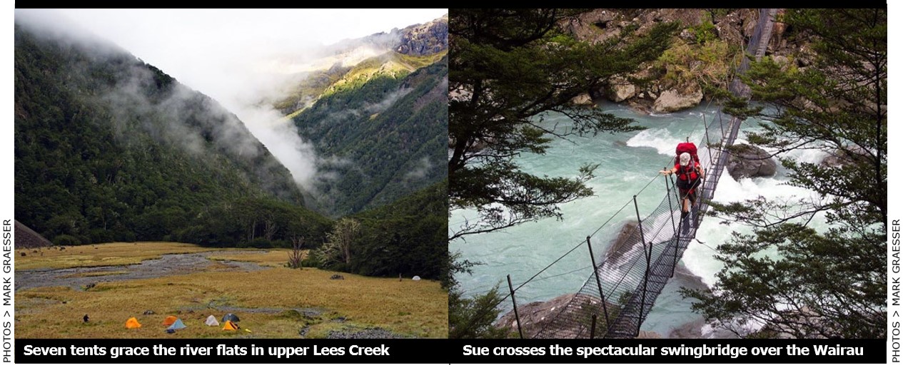
The dreaded Six-mile Creek ford was shallow and in good order so we drove through to the Lees Creek car park without problems. The team of seven quickly kitted-up and we were across the Wairau River swing bridge by 10:30 am.
The weather was overcast and humid with no wind. The 1 km of track to the swing bridge across Lees Creek was in good order and we enjoyed the walk plus the rather swaying crossing. (Note: this bridge is incorrectly marked as further up the creek on topo maps and GPS.)
The track proceeds on the true left for about three hours to the hut. We moved through a very lovely mix of beech forest and tussock flats with the delightful creek gurgling gently nearby. It is neatly confined in the valley floor and had very clear water. The track is mostly easy going with plenty of opportunities for conversation and sight seeing.
At one rest point there was wonderful trilling from several bellbirds. Little other birdlife was heard above the piercing racket of late-summer cicadas although we did see several robins and fantails. Wasps were not too evident, perhaps as a result of the coolish, wet summer. (What? I got stung – ed.)
The weather turned to intermittent light drizzle by mid-afternoon. We plunged out of a forest section onto the start of the large tussock flat where the hut is located. It is an older forest service 4-bunker that was moved from Sandfly Creek about 20 years ago. The sign on the door incongruously says “Lee Creek.” It was occupied by three hunters.
Ray bagged the hut, but to his chagrin we decided not to stay and moved on up valley to find a good camp spot. Pat’s shaky memory thought there was a good camp spot right at the forks at the top of the flat. Although the bush edge of the flat was suitable for camping, the true forks were a welter of beech saplings. So, we decided to continue up the South branch.
The un-marked track on the true left is overgrown in parts. We did get concerned about our water supply when the creek disappeared under the boulders. After a steep section above a gorge the track enters a large flat about one hour from the hut. Although the main creek was still underground, a small side stream was running out of some impressive bluffs on the true right and there was excellent camping nearby. This site was quickly occupied by our array of colourful tents and we were well pleased to get established before the forecast period of evening rain.
Although the tops were beginning to clag in, there was a weak sunset and the evening was very still. We had dinner around a camp fire and thoroughly enjoyed being in such a beautiful wild place, especially those who had recently endured full huts in nearby Nelson Lakes National Park. Despite the pressures of tourism we can still readily find plenty of fantastic backcountry for ourselves.
There was some rain overnight, but Sunday dawned with clearing skies. We decided to let the tents dry out and walk further up-valley, aiming for the tarns at the head, leaving Ray reading a book. The track became even more overgrown and indistinct. Extensive falls of old rotten trees and some slips with fresh boulders indicated damage from the Kaikoura earthquake last November.
After about an hour, we reached the upper forks in more open forest which was obviously the camp spot Pat had recalled. Bluffs and scree slopes on the Mangerton Ridge tower above this grand site. Ruth Hesselyn and Ken Ridley led NTC trips up over this ridge in 2011 and 2015.
Although the bush was thinning, the ‘track’ steepens. We made a route error here and spent 30 minutes scrabbling higher through dracophyllum scrub before realising we should have stuck close to the creek. Moving back down and then up and around a shingle spur we reached a boulder field in the impressive upper basin at 1600m - well above the bushline.
As time was running out, we turned around about 1km short of the tarns. We returned to our camp site after a thoroughly enjoyable morning
A quick lunch and pack-up saw us under way by 1pm. At the hut, we noted in the log-book that, in addition to the hunters, there had been several day parties through. The trip down the main track was uneventful, apart from another wasp sting. It took us four hours from our camp site to reach the car park.
Although some were rather weary after the morning exertions, the valley was still delightful and readily sustains the in-out nature of the trip. It is interesting to note there are still none of the wilding pines that infest the nearby catchments in Marlborough (e.g. the Branch River). Lees Creek really is one of the gems in this region, east of NLNP.
Explorers were: Patrick Holland (leader & scribe), Ray Salisbury, Ian Morris, Sue Henley, Kelvin Drew, Mark Graesser & Don Morrisey.